About Me
Banteay Prey Nokor
Banteay Prey Nokor
History
The temple complex of Banteay Prey Nokor is especially known by the temple of Wat Nokor located in Khum of Kompong Siem, at a distance of 1200 meters from the town of Kompong Cham. The monument was built out of sandstone and laterite, and dates from the last years of the reign of Jayavarman VII. It is composed of a central tower surrounded by four laterite wall-enclosures. The central tower of the temple of Vat Nokor is decorated with motifs characteristic of Bayon with Buddhist scenes on the pediments.[1] The temple complex is also believed to have been the headquarters of Jayavarman VII for a time, from where he extended his influence over nearby principalities.[2]
The local people sometimes call the temple 'Wat Angkor' though a sign at the entrance of the temple now officially designates the name of the temple as Wat Nokor Bachey. The temple has a number of distinguishing characteristics other than the fact that it is the largest ancient temple complex in Kampong Cham Province. One of these characteristics alludes to the fact that it is built of black sandstone, which causes it to stand out from other temples of the period which are often built of brick or reddish sandstone. The temple has an inscription which is still open to visitors to see (and even touch) in the temple's central pavilion. The temple also boasts a 'Chartre' effect in which another more modern temple of a very different style has been built over and around the original Angkorian structure creating a blend of architectural styles. There are many legends surrounding the origin of the temple but the most popular one has Oedipal overtones. According to this legend, the temple was built by a king who accidentally killed his father and married his mother. As recounted in the Greek legend, this King was put out by his father after a seer told him that his son would kill him. The son, however, did not die and returned to his kingdom not knowing that his father was the King. After quareling on the road, the son killed the King and married his Queen who was his mother. Upon discovering his crime, this young man built Wat Nokor in penance for his crime.

Wat Nokor does not get the attention or maintenance that it deserves with its poorly maintained grounds and gardens. The temple has great potential as a tourist attraction but is not yet adequately developed. Some people feel that the often deserted ambience of the temple is one of its greatest attractions and distinguishes it from the over touristed atmosphere found in Siem Reap and other popular tourist locations. Nevertheless, the litter strewn walks around the temple do not do justice to this ancient jewel of Kampong Cham.

ប្រភព៖ Tourism Cambodia
Phnom Chiso
Phnom Chiso is a historical site located in Sia village, Rovieng
commune, Samrong district, about 62 kilometers south of Phnom Penh or 27
kilometers north of Takeo provincial town. To reach the site, take
National Road 2 to Bati district and Neang Khmao temple. Turn right at
the sign for the site and head down the dirt trial for 5 more
kilometers. Phnom Chiso is 13O-meter-high mountain.
 Phnom Chiso
temple was built in the early 11th century by King Suryavarman I (AD
1002-1050), who practiced Brahmanism. Constructed of sandstone and other
stones, it is 60 meters long and 50 meters wide and sits atop a
mountain. The temple is surrounded by two galleries. The first gallery
is 60 meters long on each side. The second, smaller gallery, is in the
middle, where there is the main worship place with two doors and a
wooden statue. There are beautiful sculptures on the lintel and the
pillars.
Phnom Chiso
temple was built in the early 11th century by King Suryavarman I (AD
1002-1050), who practiced Brahmanism. Constructed of sandstone and other
stones, it is 60 meters long and 50 meters wide and sits atop a
mountain. The temple is surrounded by two galleries. The first gallery
is 60 meters long on each side. The second, smaller gallery, is in the
middle, where there is the main worship place with two doors and a
wooden statue. There are beautiful sculptures on the lintel and the
pillars.

Phnom Chiso Pagoda was built in 1917, destroyed by war during the 1970s and rebuilt in 1979. Behind it is a hall called Thammasaphea, kof and a worship place. There is an ancient water tank made of concrete. People usually climb the staircase on the west side of the mountain, which has 390 steps and descend by the south side staircase, which has 408 steps. Another set of stairs in front of the temple links the temple to Sen Chhmos temple, Sen Phouvang temple and Tonie Om, a lake considered sacred by Brahmans and used for washing away sins. A large rock yard nearby about 100 meters long and 80 meters was once the site of several other temples, but only parts of these temples remain standing.

In addition, there is a mountain cave, Vimean Chan, located about 150 meters south of the temple. It is a quiet place for Brahmans or ascetics to meditate. During the Americans' war with Vietnam, the site was bombed, dislodging several large rocks that block the entrance to the cave today.
Hun Sen Phnom Chiso Agricultural and Tourist site is located in Samrong, Bati and Prey Kabas districts. It includes a 513 hectare paddy rice field of dry rice, a 1,386 hectares field of wet rice and three water basins - Thnos Ta Kong, Tuol Lork and Sen Pea Ream.
Phnom Chiso is very popular with visitors, especially during festivals, when it is very crowded. The top of the mountain affords visitors a panoramic view of Takeo Province rice paddies stretching for kilometers.
 ប្រភព៖ Tourism Cambodia


Phnom Chiso Pagoda was built in 1917, destroyed by war during the 1970s and rebuilt in 1979. Behind it is a hall called Thammasaphea, kof and a worship place. There is an ancient water tank made of concrete. People usually climb the staircase on the west side of the mountain, which has 390 steps and descend by the south side staircase, which has 408 steps. Another set of stairs in front of the temple links the temple to Sen Chhmos temple, Sen Phouvang temple and Tonie Om, a lake considered sacred by Brahmans and used for washing away sins. A large rock yard nearby about 100 meters long and 80 meters was once the site of several other temples, but only parts of these temples remain standing.

In addition, there is a mountain cave, Vimean Chan, located about 150 meters south of the temple. It is a quiet place for Brahmans or ascetics to meditate. During the Americans' war with Vietnam, the site was bombed, dislodging several large rocks that block the entrance to the cave today.
Hun Sen Phnom Chiso Agricultural and Tourist site is located in Samrong, Bati and Prey Kabas districts. It includes a 513 hectare paddy rice field of dry rice, a 1,386 hectares field of wet rice and three water basins - Thnos Ta Kong, Tuol Lork and Sen Pea Ream.
Phnom Chiso is very popular with visitors, especially during festivals, when it is very crowded. The top of the mountain affords visitors a panoramic view of Takeo Province rice paddies stretching for kilometers.

Phimeanakas Temple
Phimeanakas (Khmer: ប្រាសាទភិមានអាកាស, Prasat Phimean Akas, 'celestial temple') or Vimeanakas (Khmer: ប្រាសាទវិមានអាកាស, Prasat Vimean Akas) at Angkor, Cambodia, is a Hindu temple in the Khleang style, built at the end of the 10th century, during the reign of Rajendravarman (from 941-968), then rebuilt by Suryavarman I
in the shape of a three tier pyramid as a Hindu temple. On top of the
pyramid there was a tower, while on the edge of top platform there are
galleries. Phimeanakas is located inside the walled enclosure of the
Royal Palace of Angkor Thom north of Baphuon.[1]

The temple was the focal point of Suryavarman I's capital. The buildings there from his reign are enclosed by a wall 600 by 250 m, with five gopuram, and include the Southern and Northern Khleangs.[2]:95
The tower must originally have been crowned with a golden pinnacle, as Zhou Daguan described it in his report. According to legend, the king spent the first watch of every night with a woman thought to represent a Nāga in the tower, during that time, not even the queen was permitted to intrude. Only in the second watch the king returned to his palace with the queen. If the naga who was the supreme land owner of Khmer land did not show up for a night, the king's day would be numbered, if the king did not show up, calamity would strike his land.[3]


ប្រភព៖ Tourism Cambodia
Phnom Bakheng
Phnom Bakheng (Khmer: ប្រាសាទភ្នំបាខែង) at Angkor, Cambodia, is a Hindu and Buddhist temple in the form of a temple mountain. Dedicated to Shiva, it was built at the end of the 9th century, during the reign of King Yasovarman (889-910). Located atop a hill, it is nowadays a popular tourist spot for sunset views of the much bigger temple Angkor Wat,
which lies amid the jungle about 1.5 km to the southeast. The large
number of visitors makes Phnom Bakheng one of the most threatened
monuments of Angkor. [1] Since 2004, World Monuments Fund has been working to conserve the temple in partnership with APSARA.
Constructed more than two centuries before Angkor Wat, Phnom Bakheng was in its day the principal temple of the Angkor region, historians believe. It was the architectural centerpiece of a new capital, Yasodharapura, that Yasovarman built when he moved the court from the capital Hariharalaya in the Roluos area located to the southeast.
An inscription dated 1052 AD and found at the Sdok Kak Thom temple in present-day Thailand states in Sanskrit:
"When Sri Yasovardhana became king under the name of Yasovarman, the
able Vamasiva continued as his guru. By the king's order, he set up a
linga on Sri Yasodharagiri, a mountain equal in beauty to the king of
mountains."[1]
Scholars believe that this passage refers to the consecration of the
Phnom Bakheng temple approximately a century and a half earlier.
Surrounding the mount and temple, labor teams built an outer moat. Avenues radiated out in the four cardinal directions from the mount. A causeway ran in a northwest-southeast orientation from the old capital area to the east section of the new capital's outer moat and then, turning to an east-west orientation, connected directly to the east entrance of the temple.[2]
 Phnom Bakheng is a symbolic representation of Mount Meru, home of the Hindu
gods, a status emphasized by the temple’s location atop a steep hill.
The temple faces east, measures 76 meters square at its base and is
built in a pyramid form of six tiers. At the top level, five sandstone
sanctuaries, in various states of repair, stand in a quincunx
pattern—one in the center and one at each corner of the level’s square.
Originally, 108 small towers were arrayed around the temple at ground
level and on various of its tiers; most of them have collapsed.[3]
Phnom Bakheng is a symbolic representation of Mount Meru, home of the Hindu
gods, a status emphasized by the temple’s location atop a steep hill.
The temple faces east, measures 76 meters square at its base and is
built in a pyramid form of six tiers. At the top level, five sandstone
sanctuaries, in various states of repair, stand in a quincunx
pattern—one in the center and one at each corner of the level’s square.
Originally, 108 small towers were arrayed around the temple at ground
level and on various of its tiers; most of them have collapsed.[3]

Jean Filliozat of the Ecole Francaise, a leading authority on Indian cosmology and astronomy, interpreted the symbolism of the temple. The temple sits on a rectangular base and rises in five levels and is crowned by five main towers. One hundred four smaller towers are distributed over the lower four levels, placed so symmetrically that only 33 can be seen from the center of any side. Thirty-three is the number of gods who dwelt on Mount Meru. Phnom Bakheng's total number of towers is also significant. The center one represents the axis of the world and the 108 smaller ones represent the four lunar phases, each with 27 days. The seven levels of the monument represent the seven heavens and each terrace contains 12 towers which represent the 12-year cycle of Jupiter. According to University of Chicago scholar Paul Wheatley, it is "an astronomical calendar in stone." [4]

 Phnom Bakheng is one of three hilltop temples in the Angkor region that are attributed to Yasovarman's reign. The other two are Phnom Krom to the south near the Tonle Sap lake, and Phnom Bok, northeast of the East Baray reservoir.
Following Angkor's rediscovery by the outside world in the mid-19th century, decades passed before archeologists grasped Phnom Bakheng's historical significance. For many years, scholars' consensus view was that the Bayon, the temple located at the center of Angkor Thom city, was the edifice to which the Sdok Kak Thom inscription referred. Later work identified the Bayon as a Buddhist site, built almost three centuries later than originally thought, in the late 12th century, and Phnom Bakheng as King Yasovarman's state temple.

ប្រភព៖ Tourism Cambodia
Constructed more than two centuries before Angkor Wat, Phnom Bakheng was in its day the principal temple of the Angkor region, historians believe. It was the architectural centerpiece of a new capital, Yasodharapura, that Yasovarman built when he moved the court from the capital Hariharalaya in the Roluos area located to the southeast.
 |
Surrounding the mount and temple, labor teams built an outer moat. Avenues radiated out in the four cardinal directions from the mount. A causeway ran in a northwest-southeast orientation from the old capital area to the east section of the new capital's outer moat and then, turning to an east-west orientation, connected directly to the east entrance of the temple.[2]


Jean Filliozat of the Ecole Francaise, a leading authority on Indian cosmology and astronomy, interpreted the symbolism of the temple. The temple sits on a rectangular base and rises in five levels and is crowned by five main towers. One hundred four smaller towers are distributed over the lower four levels, placed so symmetrically that only 33 can be seen from the center of any side. Thirty-three is the number of gods who dwelt on Mount Meru. Phnom Bakheng's total number of towers is also significant. The center one represents the axis of the world and the 108 smaller ones represent the four lunar phases, each with 27 days. The seven levels of the monument represent the seven heavens and each terrace contains 12 towers which represent the 12-year cycle of Jupiter. According to University of Chicago scholar Paul Wheatley, it is "an astronomical calendar in stone." [4]


Following Angkor's rediscovery by the outside world in the mid-19th century, decades passed before archeologists grasped Phnom Bakheng's historical significance. For many years, scholars' consensus view was that the Bayon, the temple located at the center of Angkor Thom city, was the edifice to which the Sdok Kak Thom inscription referred. Later work identified the Bayon as a Buddhist site, built almost three centuries later than originally thought, in the late 12th century, and Phnom Bakheng as King Yasovarman's state temple.
ប្រភព៖ Tourism Cambodia
Preah khan Temple
Preah Khan (Khmer: ប្រាសាទព្រះខ័ន; "Royal Sword") is a temple at Angkor, Cambodia, built in the 12th century for King Jayavarman VII. It is located northeast of Angkor Thom and just west of the Jayatataka baray, with which it was associated. It was the centre of a substantial organisation, with almost 100,000 officials and servants. The temple is flat in design, with a basic plan of successive rectangular galleries around a Buddhist sanctuary complicated by Hindu satellite temples and numerous later additions. Like the nearby Ta Prohm, Preah Khan has been left largely unrestored, with numerous trees and other vegetation growing among the ruins.

History
Preah Khan was built on the site of Jayavarman VII's victory over the invading Chams in 1191. Unusually the modern name, meaning "holy sword", is derived from the meaning of the original—Nagara Jayasri (holy city of victory).[1] The site may previously have been occupied by the royal palaces of Yasovarman II and Tribhuvanadityavarman.[2] The temple's foundation stela has provided considerable information about the history and administration of the site: the main image, of the bodhisattva Avalokiteśvara in the form of the king's father, was dedicated in 1191 (the king's mother had earlier been commemorated in the same way at Ta Prohm). 430 other deities also had shrines on the site, each of which received an allotment of food, clothing, perfume and even mosquito nets;[3] the temple's wealth included gold, silver, gems, 112,300 pearls and a cow with gilded horns.[4] The institution combined the roles of city, temple and Buddhist university: there were 97,840 attendants and servants, including 1000 dancers[5] and 1000 teachers.[6]The temple is still largely unrestored: the initial clearing was from 1927 to 1932, and partial anastylosis was carried out in 1939. Since then free-standing statues have been removed for safe-keeping, and there has been further consolidation and restoration work. Throughout, the conservators have attempted to balance restoration and maintenance of the wild condition in which the temple was discovered: one of them, Maurice Glaize, wrote that;
The temple was previously overrun with a particularly voracious vegetation and quite ruined, presenting only chaos. Clearing works were undertaken with a constant respect for the large trees which give the composition a pleasing presentation without constituting any immediate danger. At the same time, some partial anastylosis has revived various buildings found in a sufficient state of preservation and presenting some special interest in their architecture or decoration.[7]Since 1991, the site has been maintained by the World Monuments Fund. It has continued the cautious approach to restoration, believing that to go further would involve too much guesswork, and prefers to respect the ruined nature of the temple. One of its former employees has said, "We're basically running a glorified maintenance program. We're not prepared to falsify history".[8] It has therefore limited itself primarily to stabilisation work on the fourth eastern gopura, the House of Fire and the Hall of Dancers.[9]
 |
| Preah Khan Temple |
The site


The fourth enclosure wall bears 5 m garudas holding nagas. Buddha images in the niches above were destroyed in the anti-Buddhist reaction of Jayavarman VIII.
Halfway along the path leading to the third enclosure, on the north side, is a House of Fire (or Dharmasala) similar to Ta Prohm's. The remainder of the fourth enclosure, now forested, was originally occupied by the city; as this was built of perishable materials it has not survived. The third enclosure wall is 200 by 175 metres (656 by 574 ft). In front of the third gopura is a cruciform terrace. The gopura itself is on a large scale, with three towers in the centre and two flanking pavilions. Between the southern two towers were two celebrated silk-cotton trees, of which Glaize wrote, "resting on the vault itself of the gallery, [they] frame its openings and brace the stones in substitute for pillars in a caprice of nature that is as fantastic as it is perilous."[11] One of the trees is now dead, although the roots have been left in place. The trees may need to be removed to prevent their damaging the structure.[12] On the far side of the temple, the third western gopura has pediments of a chess game and the Battle of Lanka, and two guardian dvarapalas to the west.

The purpose of this two-storied building with round columns is unknown.
Connecting the Hall of Dancers and the wall of the second enclosure is a courtyard containing two libraries. The second eastern gopura projects into this courtyard; it is one of the few Angkorian gopuras with significant internal decoration, with garudas on the corners of the cornices. Buddha images on the columns were changed into hermits under Jayavarman VIII.
Between the second enclosure wall (85 by 76 m or 279 by 249 ft) and the first enclosure wall (62 by 55 m or 203 by 180 ft) on the eastern side is a row of later additions which impede access and hide some of the original decoration. The first enclosure is, as Glaize said, similarly, "choked with more or less ruined buildings".[15] The enclosure is divided into four parts by a cruciform gallery, each part almost filled by these later irregular additions. The walls of this gallery, and the interior of the central sanctuary, are covered with holes for the fixing of bronze plates which would originally have covered them and the outside of the sanctuary—1500 tonnes was used to decorate the whole temple.[16] At the centre of the temple, in place of the original statue of Lokesvara, is a stupa built several centuries after the temple's initial construction.
Microbial degradation
Microbial biofilms have been found degrading sandstone at Angkor Wat, Preah Khan, and the Bayon and West Prasat in Angkor. The dehydration and radiation resistant filamentous cyanobacteria can produce organic acids that degrade the stone. A dark filamentous fungus was found in internal and external Preah Khan samples, while the alga Trentepohlia was found only in samples taken from external, pink-stained stone at Preah Khan.[1]ប្រភព៖ Tourism Cambodia
Banteay Srei Temple
Banteay Srei or Banteay Srey (Khmer: ប្រាសាទបន្ទាយស្រី) is a 10th-century Cambodian temple dedicated to the Hindu god Shiva. Located in the area of Angkor in Cambodia. It lies near the hill of Phnom Dei, 25 km (16 mi) north-east of the main group of temples that once belonged to the medieval capitals of Yasodharapura and Angkor Thom.[1] Banteay Srei is built largely of red sandstone,
a medium that lends itself to the elaborate decorative wall carvings
which are still observable today. The buildings themselves are miniature
in scale, unusually so when measured by the standards of Angkorian
construction. These factors have made the temple extremely popular with
tourists, and have led to its being widely praised as a "precious gem",
or the "jewel of Khmer art."[2]
Consecrated on 22 April 967 A.D.,[3] Bantãy Srĕi was the only major temple at Angkor not built by a monarch; its construction is credited to a courtier named Yajnavaraha / Yajñavarāha (modern Khmer: យជ្ញវរាហៈ), who served as a counsellor to king Rajendravarman II (modern Khmer: ព្រះបាទរាជេន្រ្ទវរ្ម័ន).The foundational stela says that Yajnavaraha,
grandson of king Harsavarman I, was a scholar and philanthropist who
helped those who suffered from illness, injustice, or poverty.[4]
His pupil was the future king Jayavarman V (r. 968- ca. 1001).
Originally, the temple was surrounded by a town called Īśvarapura.
 Yajñavarāha's temple was primarily dedicated to the Hindu god Śiva. Originally, it was carried the name Tribhuvanamaheśvara—great lord of the threefold world—in reference to the Shaivite linga that served as its central religious image.[6]
However, the temple buildings appear to be divided along the central
east-west axis between those buildings located south of the axis, which
are devoted to Śiva, and those north of the axis, which are devoted to Viṣṇu.
Yajñavarāha's temple was primarily dedicated to the Hindu god Śiva. Originally, it was carried the name Tribhuvanamaheśvara—great lord of the threefold world—in reference to the Shaivite linga that served as its central religious image.[6]
However, the temple buildings appear to be divided along the central
east-west axis between those buildings located south of the axis, which
are devoted to Śiva, and those north of the axis, which are devoted to Viṣṇu.
 The temple's modern name, Bantãy Srĕi—citadel of the women, or citadel of beauty—is probably related to the intricacy of the bas relief carvings found on the walls and the tiny dimensions of the buildings themselves.[6] Some have speculated that it relates to the many devatas carved into the walls of the buildings.[7]
A brief study on Chola-built temples in Kampuchea (Cambodia)
With this good Chola-Khamer relationship the Saivite Priests, Traders and Stone Sculpturers from Chola country gradually settled in the region of Angkor the capital city of the Khamer emperor Suriyavarman - 1. During this period an old Siva Temple at 'Banteay Srei' 30 km from the Angkor Wat temple in Cambodia was 'expanded and new sections were added to an existing Siva temple' evidently by the Chola forces and re-dedicated to God Siva, with the new name "Thiribuvanamahadeva Temple" after Rajendra Chola's own mother's name the "Thiribhuvanamahadevi".
In this temple in its second enclosure, on the Gopura over main entrance we see an image of Nadarajah represented with eight hands but not in the same style as the Nadarajah images in the Tamil Nadu with left leg lifted and with four hands. In the lower panel beneath the Nadarajah image on its right side we see an image of a Drummer playing the drums to the beat of the Dance of God Siva depicted as Nadarajah, and on the left we see an image "visibly and positively confirmed" as that of the Kaaraikaal Ammaiyar of the Chola Country being one of the 63 - Tamil Saiva Saints of Tamil Nadu. This Panel undoubtedly was carved by a Tamil Sculpturer apparently from Chola country in Tamil Nadu.
The Image of the Stone Panel at 'Banteay Srei' Siva Temple in Angkor, Cambodia, with the images of Nadarajah & Kaaraikkaal Ammaiyar can be reached and viewed on the following URL. (Enlarge this Image on your Computer to see the image of Kaaraikaal Ammaiyaar clearly with her ghostly Face and lean body with Ribs showing and holding a mango fruit in the right hand, an image of Kaaraikkaal Ammaiyaar comparable with the other images of her found in Tamil Nadu and in Polonnaruwa in Sri Lanka.
http://upload.wikimedia.org/wikipedi...lintelsrei.JPG
A pediment is the roughly triangular space above a rectangular doorway or openings. At Banteay Srei, pediments are relatively large in comparison to the openings below, and take a sweeping gabled shape. For the first time in the history of Khmer architecture, whole scenes of mythological subject-matter are depicted on the pediments.
A lintel is a horizontal beam spanning the gap between two posts. Some lintels serve a structural purpose, serving to support the weight of the superstructure, while others are purely decorative in purpose. The lintels at Banteay Srei are beautifully carved, rivalling those of the 9th century Preah Ko style in quality.
 Noteworthy decorative motifs include the kala (a toothy monster symbolic of time), the guardian dvarapala (an armed protector of the temple) and devata (demi-goddess), the false door, and the colonette.[17] Indeed, decorative carvings seem to cover almost every available surface. According to pioneering Angkor scholar Maurice Glaize,
"Given the very particular charm of Banteay Srei – its remarkable state
of preservation and the excellence of a near perfect ornamental
technique – one should not hesitate, of all the monuments of the Angkor
group, to give it the highest priority." At Banteay Srei, wrote Glaize,
"the work relates more closely to the art of the goldsmith or to carving in wood than to sculpture in stone".[12]
Noteworthy decorative motifs include the kala (a toothy monster symbolic of time), the guardian dvarapala (an armed protector of the temple) and devata (demi-goddess), the false door, and the colonette.[17] Indeed, decorative carvings seem to cover almost every available surface. According to pioneering Angkor scholar Maurice Glaize,
"Given the very particular charm of Banteay Srei – its remarkable state
of preservation and the excellence of a near perfect ornamental
technique – one should not hesitate, of all the monuments of the Angkor
group, to give it the highest priority." At Banteay Srei, wrote Glaize,
"the work relates more closely to the art of the goldsmith or to carving in wood than to sculpture in stone".[12]
 The third enclosure is 95 by 110 m; it is surrounded by a laterite wall breached by gopuras at the eastern and western ends.[20] Neither pediment of the eastern gopura is in situ. The west-facing pediment is now located in the Musée Guimet in Paris.[19] It depicts a scene from the Mahabhārata in which the Asura brothers Sunda and Upasunda fight over the Apsara Tilottama. The east-facing pediment is lying on the ground. It depicts a scene from the Rāmāyaṇa in which a demon seizes Rama's wife Sita.[21] Most of the area within the third enclosure is occupied by a moat divided into two parts by causeways to the east and west.
 The second enclosure sits between an outer laterite wall measuring 38
by 42 m, with gopuras at the eastern and western ends, and a brick
inner enclosure wall, measuring 24 by 24 m.[20] The western gopura features an interesting bas relief depicting the duel of the monkey princes Vāli and Sugriva, as well as Rāma's
intervention on Sugrīva's behalf. The inner enclosure wall has
collapsed, leaving a gopura at the eastern end and a brick shrine at the
western. The eastern pediment of the gopura shows Śiva Nataraja; the west-facing pediment has an image of Karaikal Ammaiyar, one of the three women amongst the sixty three Nayanmars (hounds of Śiva).[22]
Likewise, the laterite galleries which once filled the second enclosure
(one each to north and south, two each to east and west) have partially
collapsed. A pediment on one of the galleries shows the lion-man Narasiṃha clawing the demon Hiranyakashipu.
The second enclosure sits between an outer laterite wall measuring 38
by 42 m, with gopuras at the eastern and western ends, and a brick
inner enclosure wall, measuring 24 by 24 m.[20] The western gopura features an interesting bas relief depicting the duel of the monkey princes Vāli and Sugriva, as well as Rāma's
intervention on Sugrīva's behalf. The inner enclosure wall has
collapsed, leaving a gopura at the eastern end and a brick shrine at the
western. The eastern pediment of the gopura shows Śiva Nataraja; the west-facing pediment has an image of Karaikal Ammaiyar, one of the three women amongst the sixty three Nayanmars (hounds of Śiva).[22]
Likewise, the laterite galleries which once filled the second enclosure
(one each to north and south, two each to east and west) have partially
collapsed. A pediment on one of the galleries shows the lion-man Narasiṃha clawing the demon Hiranyakashipu.
 The east-facing pediment on the southern library shows Śiva seated on the summit of Mount Kailāsa, his mythological abode. His consort Umā
sits on his lap and clings anxiously to his torso. Other beings are
also present on the slopes of the mountain, arranged in a strict
hierarchy of three tiers from top to bottom. In the top tier sit bearded
wise men and ascetics, in the middle tier mythological figures with the
heads of animals and the bodies of humans, and in the bottom tier large
animals, including a number of lions. In the middle of the scene stands
the ten-headed demon king Rāvaṇa.
He is shaking the mountain in its very foundations as the animals flee
from his presence and as the wise men and mythological beings discuss
the situation or pray. According to the legend, Śiva stopped Rāvaṇa from
shaking the mountain by using his toe to press down on the mountain and
to trap Rāvana underneath for 1000 years.[24]
The east-facing pediment on the southern library shows Śiva seated on the summit of Mount Kailāsa, his mythological abode. His consort Umā
sits on his lap and clings anxiously to his torso. Other beings are
also present on the slopes of the mountain, arranged in a strict
hierarchy of three tiers from top to bottom. In the top tier sit bearded
wise men and ascetics, in the middle tier mythological figures with the
heads of animals and the bodies of humans, and in the bottom tier large
animals, including a number of lions. In the middle of the scene stands
the ten-headed demon king Rāvaṇa.
He is shaking the mountain in its very foundations as the animals flee
from his presence and as the wise men and mythological beings discuss
the situation or pray. According to the legend, Śiva stopped Rāvaṇa from
shaking the mountain by using his toe to press down on the mountain and
to trap Rāvana underneath for 1000 years.[24]
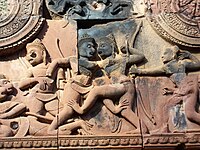
The west-facing pediment on southern library shows Śiva again seated on the summit of Mount Kailāsa. He is looking to his left at the god of love Kāma, who is aiming an arrow at him. Umā sits to Śiva's right; he is handing her a chain of beads. The slopes of the mountain are crowded with other beings, again arranged in a strict hierarchy from top to bottom. Just under Śiva sits a group of bearded wise men and ascetics, under whom the second tier is occupied by the mythological beings with the heads of animals and the bodies of humans; the lowest tier belongs the common people, who mingle sociably with tame deer and a large gentle bull. According to the legend, Kāma fired an arrow at Śiva in order to cause Śiva to take an interest in Umā. Śiva, however, was greatly angered by this provocation, and punished Kāma by gazing upon him with his third eye, frying Kāma to cinders.[24]
 The east-facing pediment on the northern library shows the god of the sky Indra creating rain to put out a forest fire started by the god of fire Agni for purposes of killing the nāga king Takshaka who lived in Khandava Forest. The Mahābhāratan heroes Kṛṣṇa and Arjuna
are shown helping Agni by firing a dense hail of arrows to block
Indra's rain. Takṣaka's son Aśvasena is depicted attempting to escape
from the conflagration, while other animals stampede about in panic.
The east-facing pediment on the northern library shows the god of the sky Indra creating rain to put out a forest fire started by the god of fire Agni for purposes of killing the nāga king Takshaka who lived in Khandava Forest. The Mahābhāratan heroes Kṛṣṇa and Arjuna
are shown helping Agni by firing a dense hail of arrows to block
Indra's rain. Takṣaka's son Aśvasena is depicted attempting to escape
from the conflagration, while other animals stampede about in panic.
The west-facing pediment on the southern library depicts Kṛṣṇa slaying his wicked uncle Kamsa.[25]
 The sanctuary is entered from the east by a doorway only 1.08 m in height: inside is an entrance chamber (or maṇḍapa) with a corbelled
brick roof, then a short corridor leading to three towers to the west:
the central tower is the tallest, at 9.8 m. Glaize notes the impression
of delicacy given the towers by the antefixes
on each of their tiers. The six stairways leading up to the platform
were each guarded by two kneeling statues of human figures with animal
heads; most of those now in place are replicas, the originals having
been stolen or removed to museu
The sanctuary is entered from the east by a doorway only 1.08 m in height: inside is an entrance chamber (or maṇḍapa) with a corbelled
brick roof, then a short corridor leading to three towers to the west:
the central tower is the tallest, at 9.8 m. Glaize notes the impression
of delicacy given the towers by the antefixes
on each of their tiers. The six stairways leading up to the platform
were each guarded by two kneeling statues of human figures with animal
heads; most of those now in place are replicas, the originals having
been stolen or removed to museu
ms.
ប្រភព៖ Tourism Cambodia
History
Foundation and dedication


It has been speculated that the temple's modern name, Bantãy Srĕi, is due to the many devatas carved into the red sandstone walls.
A brief study on Chola-built temples in Kampuchea (Cambodia)
With this good Chola-Khamer relationship the Saivite Priests, Traders and Stone Sculpturers from Chola country gradually settled in the region of Angkor the capital city of the Khamer emperor Suriyavarman - 1. During this period an old Siva Temple at 'Banteay Srei' 30 km from the Angkor Wat temple in Cambodia was 'expanded and new sections were added to an existing Siva temple' evidently by the Chola forces and re-dedicated to God Siva, with the new name "Thiribuvanamahadeva Temple" after Rajendra Chola's own mother's name the "Thiribhuvanamahadevi".
In this temple in its second enclosure, on the Gopura over main entrance we see an image of Nadarajah represented with eight hands but not in the same style as the Nadarajah images in the Tamil Nadu with left leg lifted and with four hands. In the lower panel beneath the Nadarajah image on its right side we see an image of a Drummer playing the drums to the beat of the Dance of God Siva depicted as Nadarajah, and on the left we see an image "visibly and positively confirmed" as that of the Kaaraikaal Ammaiyar of the Chola Country being one of the 63 - Tamil Saiva Saints of Tamil Nadu. This Panel undoubtedly was carved by a Tamil Sculpturer apparently from Chola country in Tamil Nadu.
The Image of the Stone Panel at 'Banteay Srei' Siva Temple in Angkor, Cambodia, with the images of Nadarajah & Kaaraikkaal Ammaiyar can be reached and viewed on the following URL. (Enlarge this Image on your Computer to see the image of Kaaraikaal Ammaiyaar clearly with her ghostly Face and lean body with Ribs showing and holding a mango fruit in the right hand, an image of Kaaraikkaal Ammaiyaar comparable with the other images of her found in Tamil Nadu and in Polonnaruwa in Sri Lanka.
http://upload.wikimedia.org/wikipedi...lintelsrei.JPG
Expansion and rededication
Bantãy Srĕi was subject to further expansion and rebuilding work in the eleventh century.[8]:96 At some point it came under the control of the king and had its original dedication changed; the inscription K 194 from Phnoṃ Sandak, dated Monday, the 14th or 28 July 1119 A.D. records (line B 13) the temple being given to the priest Divākarapaṇḍita and being rededicated to Śiva.[9] It remained in use at least until the fourteenth century according to the last known inscription K 569, dated Thursday, 8 August 1303 A.D.[10]Restoration
The temple was rediscovered only in 1914, and was the subject of a celebrated case of art theft when André Malraux stole four devatas in 1923 (he was soon arrested and the figures returned).[11] The incident stimulated interest in the site, which was cleared the following year, and in the 1930s Banteay Srei was restored through the first important use of anastylosis at Angkor whereby a ruined building or monument is restored using the original architectural elements to the greatest degree possible. Until the discovery of the foundation stela in 1936, it had been assumed that the extreme decoration indicated a later date than was in fact the case.[12] To prevent the site from water damage, the joint Cambodian-Swiss Banteay Srei Conservation Project installed a drainage system between 2000 and 2003.[13] Measures were also taken to prevent damage to the temples walls from nearby trees.[14] Unfortunately, the temple has been ravaged by pilfering and vandalism. When toward the end of the 20th century authorities removed some original statues and replaced them with concrete replicas, looters took to attacking the replicas. A statue of Shiva and his shakti Uma, removed to the National Museum in Phnom Penh for safekeeping, was assaulted in the museum itself.[15]Materials and style
Banteay Srei is built largely of a hard red sandstone that can be carved like wood.[16] Brick and laterite were used only for the enclosure walls and some structural elements. The temple is known for the beauty of its sandstone lintels and pediments.A pediment is the roughly triangular space above a rectangular doorway or openings. At Banteay Srei, pediments are relatively large in comparison to the openings below, and take a sweeping gabled shape. For the first time in the history of Khmer architecture, whole scenes of mythological subject-matter are depicted on the pediments.
A lintel is a horizontal beam spanning the gap between two posts. Some lintels serve a structural purpose, serving to support the weight of the superstructure, while others are purely decorative in purpose. The lintels at Banteay Srei are beautifully carved, rivalling those of the 9th century Preah Ko style in quality.

Many niches in the temple walls contain carvings of devatas or dvarapalas.
The site
The site consists of three concentric rectangular enclosures constructed on an east–west axis. A causeway situated on the axis leads from an outer gopura, or gate, to the third or outermost of the three enclosures. The inner enclosure contains the sanctuary, consisting of an entrance chamber and three towers, as well as two buildings conventionally referred to as libraries.The outer gopura
The gopura is all that remains of the outer wall surrounding the town of Isvapura. The wall is believed to have measured approximately 500 m square, and may have been constructed of wood. The gopura's eastern pediment shows Indra, who was associated with that direction, mounted on his three-headed elephant Airavata.[18] The 67 m causeway with the remains of corridors on either side connects the gopura with the third enclosure. North and south of this causeway are galleries with a north–south orientation.The third (outer) enclosure

The pediment representing the fight between the asura brothers Sunda and Upasunda over the apsaras Tilottamā is located in the Musée Guimet.[19]
The second enclosure
The second enclosure

The combat between Vāli and Sugrīva is depicted on the western gopura.

Śiva Nāṭarāja is depicted on the eastern gopura of the inner enclosure wall.
The first (inner) enclosure
Between the gopuras on the collapsed inner wall are the buildings of the inner enclosure: a library in the south-east corner and another in the north-east corner, and in the centre the sanctuary set on a T-shaped platform 0.9 m high. Besides being the most extravagantly decorated parts of the temple, these have also been the most successfully restored (helped by the durability of their sandstone and their small scale). In 2010, the first enclosure is open to visitors again, but the inner temples are roped off and inaccessible.The libraries
The two libraries are of brick, laterite and sandstone. Each library has two pediments, one on the eastern side and one on the western. According to Maurice Glaize, the four library pediments, "representing the first appearance of tympanums with scenes, are works of the highest order. Superior in composition to any which followed, they show true craftsmanship in their modelling in a skilful blend of stylisation and realism."[23]
The intricate reliefs carving of red colored stone.
The west-facing pediment on southern library shows Śiva again seated on the summit of Mount Kailāsa. He is looking to his left at the god of love Kāma, who is aiming an arrow at him. Umā sits to Śiva's right; he is handing her a chain of beads. The slopes of the mountain are crowded with other beings, again arranged in a strict hierarchy from top to bottom. Just under Śiva sits a group of bearded wise men and ascetics, under whom the second tier is occupied by the mythological beings with the heads of animals and the bodies of humans; the lowest tier belongs the common people, who mingle sociably with tame deer and a large gentle bull. According to the legend, Kāma fired an arrow at Śiva in order to cause Śiva to take an interest in Umā. Śiva, however, was greatly angered by this provocation, and punished Kāma by gazing upon him with his third eye, frying Kāma to cinders.[24]

Another pediment shows the burning of Khāṇḍava Forest.
The west-facing pediment on the southern library depicts Kṛṣṇa slaying his wicked uncle Kamsa.[25]
The sanctuary

The mandapa and central tower, seen from the northeast.
ms.
ប្រភព៖ Tourism Cambodia


